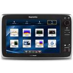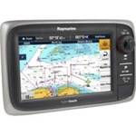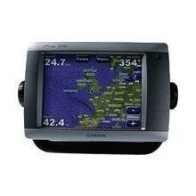
GPSMAP 5208 - Marine GPS receiver - 8.4" color - 6
Model: 5208
Brand: Garmin
This flagship marine navigator is missing just one thing - buttons. The GPSMAP 5208 features an unprecedented touchscreen interface, along with preloaded BlueChart g2 maps of the U.S. coast and an 8.4\" screen that makes navigation as easy as pointing your finger. By connecting to the Garmin Marine Network, you can add sonar, radar and weather. The GPSMAP 5208 features highly-detailed BlueChart g2 marine cartography of the costal United States, including Alaska, Hawaii and the Bahamas. For other areas, the 5208 has a worldwide basemap with high-quality satellite images in place of more traditional maps. With the SD card slot, you can add additional maps without having to connect to a computer. The 5208\'s large screen displays crisp, high-resolution graphics so you can easily see where you\'re going. To keep tabs on your engine room or other area of your boat, you can also connect a live video feed with the 5208\'s video input/output options. The 5208 connects easily to the high-speed Garmin Marine Network, so you can interface with additional MFDs and add remote sensors. Once connected, you can share information between the 5208 and other chartplotters on your boat. You can also add high-powered radar, sonar, and XM satellite weather and radio to your system. This product is bundled with GPS 17 with pole mount adapter. « less
Product Specifications –
- GTIN : 00753759066086
- Features : Alarm, 2D / 3D map perspective
- First Seen On Google Shopping : April 2007
- Card Reader : SD Memory Card
- Antenna : External
- Compatible Software : BlueChart g2 Vision
- Diagonal Size : 8.4"
- Depth : 4.2 in
- Height : 6.8 in
- Interface : NMEA 0183, NMEA 2000
- Included Software : Garmin Worldwide Marine Basemap
- Included Accessories : Protective cover, PC cable, mounting bracket, power cable
- Interfaces : Garmin Marine Network Composite video input
- Part Numbers : 010-00593-01, 5208
- Preloaded Maps : USA
- Waterproof Standard : IPX7
- Waypoints : 1500
- Weight : 6 lbs
- Width : 10.1 in
- Trip Computer : Sunrise/sunset times, sun/moon positions
- Type : TFT - color - touch screen
- Tracklog Points : 10000
- Tracks : 20
- Routes : 20
- SBAS : WAAS
- Resolution : 640 x 480
- Recommended Use : Marine
- Protection : Waterproof
- Product Type : GPS receiver