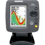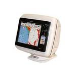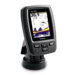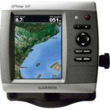
GPSMAP 526 - Marine Chartplotter - 5" color - 480
Model: 526
Brand: Garmin
The GPSMAP 526 is a compact chartplotter that features a high-resolution, super-bright 5\" VGA display along with an improved high-speed digital design for increased map drawing and panning speeds. It\'s ready to go with a built-in, satellite-enhanced worldwide basemap. The GPSMAP 526 also accepts BlueChart g2 vision cards for added features and functionality such as high-resolution satellite imagery, 3-D views and Auto Guidance technology. « less
Product Specifications –
- Height : 6.4 in
- Included Accessories : Protective cover, mounting bracket, power/data cable
- Included Software : Garmin Worldwide Marine Basemap
- Interface : NMEA 0183, NMEA 2000
- Interfaces : Antenna - BNC
- GTIN : 00753759096106
- Features : Alarm, 2D / 3D map perspective, XM Satellite Radio support, XM weather support
- Features : Anti-glare
- First Seen On Google Shopping : December 2009
- Card Reader : SD Memory Card
- Antenna : Built-in
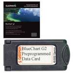
- Compatible Software : BlueChart g2 Vision
- Diagonal Size : 5"
- Depth : 2.9 in
- Part Numbers : 010-00772-00, 526
- Protection : Waterproof
- Product Type : Chartplotter
- Resolution : 480 x 640
- Recommended Use : Marine
- Routes : 100
- Type : LCD - color
- Tracklog Points : 20000
- Tracks : 50
- Trip Computer : Sun/moon positions
- Waypoints : 3000
- Weight : 1.8 lbs
- Width : 5.9 in
- Waterproof Standard : IPX7