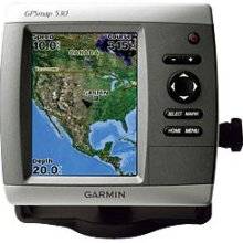
GPSMAP 530s - Marine GPS receiver - 4" color - 240
Model: 530s
Brand: Garmin
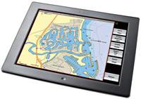
The slim-line fresh water GPSMAP 530s flush-mounts easily in your boat and sports preloaded, detailed maps for U.S. inland lakes. The 530s also features a 5\" QVGA display and simple, straightforward buttons and menus. You can add the optional BlueChart g2 Vision SD card for even more enhanced features. The 530s comes preloaded with detailed maps for U.S. inland lakes, including 5300 lakes with shoreline, depth contours, and more. Over 300 of these lakes are enhanced with extra Inland Lakes Vision features. For areas outside the U.S., the 530s has a worldwide basemap with satellite images in place of more traditional maps. The SD card slot makes it easy to add additional maps without connecting to a computer. And with just a few buttons and a simple, intuitive interface, the 530s makes navigating your way through the water easy. The 530s boasts advanced Inland Lakes Vision features for 300 of the most popular lakes. 3D mariner\'s eye view or fish eye view provides you with a 3-dimensional perspective of map information, both above the waterline and below it. Higher-resolution satellite images help you orient yourself in unfamiliar areas. Auto guidance technology searches through map data to suggest the best passage. The GPSMAP 530s comes with a powerful dual frequency or dual beam transducer that clearly paints depth contours, fish targets and structure. It\'s also CANet compatible, so you can share sounder data with another chartplotter on your boat. « less
Product Specifications –
- Part Numbers : 010-00613-00, 530s
- Waypoints : 1500
- Width : 5.9 in
- Weight : 1.8 lbs
- Waterproof Standard : IPX7
- Warm : 15 sec
- Tracks : 20
- Tracklog Points : 10000
- Trip Computer : Sunrise/sunset times, sun/moon positions
- Type : LCD - color
- Update Rate : 1/second
- Routes : 20
- SBAS : WAAS
- Recommended Use : Marine
- Receiver : 12 channel
- Resolution : 240 x 320
- Product Type : GPS receiver
- Protection : Waterproof
- Max Operating Temperature : 131 °F
- Min Operating Temperature : 5 °F
- Interface : NMEA 0183
- Included Software : MapSource BlueChart Inland Lakes: United States
- Height : 6.4 in
- Included Accessories : Transom mount transducer, protective cover, mounting bracket, power/data cable
- Interfaces : Antenna
- GTIN : 00753759065959
- First Seen On Google Shopping : March 2007
- Features : Depth sounder, alarm, 2D / 3D map perspective
- Features : Adjustable brightness
- Depth : 2.9 in
- Design Features : Rugged case
- Diagonal Size : 4"
- DGPS : DGPS ready
- Compatible Software : BlueChart g2 Vision
- Cold : 45 sec
- Card Reader : SD Memory Card
- Antenna : Built-in
- Accuracy : Position - 49 ft Velocity - 0.16 ft/sec Position - 10 ft ( with WAAS )