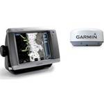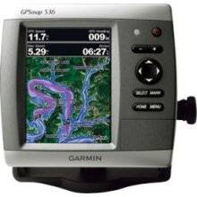
GPSMAP 536s - Marine Chartplotter - 5" color - 480
Model: 536s
Brand: Garmin
The GPSMAP 536s is a compact chartplotter that features a high-resolution, super-bright 5\" VGA color display along with an improved high-speed digital design for increased map drawing and panning speeds. It\'s ready to go with a built-in, satellite-enhanced basemap and an easy-to-use interface designed to help you navigate the open waters with ease. The GPSMAP 536s also accepts BlueChart g2 Vision cards for added features and functionality such as high-resolution satellite imagery, 3-D views and Auto Guidance technology. The GPSMAP 536s has a worldwide basemap with satellite images in place of more traditional maps. The GPSMAP 536s also comes standard with a high-sensitivity GPS receiver for superior satellite tracking and quicker acquisition times. With an SD card slot, it\'s easy to add additional maps without connecting to a computer. The GPSMAP 536s is also NMEA 2000-certified for easy connectivity with sensors, instruments and future marine offerings. « less
Product Specifications –
- Height : 6.4 in
- Included Accessories : Protective cover, mounting bracket, power/data cable
- Interface : NMEA 0183, NMEA 2000
- Included Software : MapSource BlueChart Inland Lakes: United States
- Card Reader : SD Memory Card
- Diagonal Size : 5"
- Depth : 2.9 in
- Compatible Software : BlueChart g2 Vision
- First Seen On Google Shopping : February 2011
- Features : Optional external GPS antenna connection, XM weather support
- Functions & Services : Tide Tab
- GTIN : 00753759096144
- Part Numbers : 010-00773-01, 536s
- Product Type : Chartplotter
- Protection : Waterproof
- Resolution : 480 x 640
- Recommended Use : Marine
- Routes : 100
- Type : LCD - color
- Tracks : 50
- Tracklog Points : 20000
- Trip Computer : Sun/moon positions
- Transducer Presence : Included transducer
- Transducer Type : Dual-beam
- Waypoints : 3000
- Width : 5.9 in
- Weight : 1.8 lbs
- Waterproof Standard : IPX7