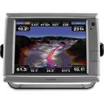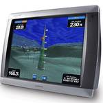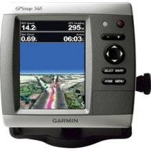
GPSMAP 546 - Marine GPS receiver - 5" color - 640
Model: 546
Brand: Garmin
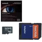
The GPSMAP 546 is a compact chartplotter that features a high-resolution, super-bright 5\" VGA color display along with an improved high-speed digital design for increased map drawing and panning speeds. It\'s ready to go with an easy-to-use interface and a built-in, satellite-enhanced basemap preloaded with all U. S. coastal areas, including Alaska and Hawaii as well as detailed charts for the Bahamas. The GPSMAP 546 also accepts BlueChart g2 Vision cards for added features and functionality such as high-resolution satellite imagery, 3-D views and Auto Guidance technology. « less
Product Specifications –
- Part Numbers : 010-00774-00, 546
- Product Type : GPS receiver
- Protection : Waterproof
- Recommended Use : Marine
- Resolution : 640 x 480
- Routes : 100
- Tracks : 50
- Tracklog Points : 20000
- Type : LCD - color
- Trip Computer : Sun/moon positions
- Width : 5.9 in
- Weight : 1.8 lbs
- Waypoints : 3000
- Waterproof Standard : IPX7
- GTIN : 00753759096151
- Functions & Services : Tide Tab
- First Seen On Google Shopping : February 2011
- Features : Depth sounder, XM weather support
- Features : Adjustable brightness
- Depth : 2.9 in
- Design Features : Rugged case
- Diagonal Size : 5"
- Compatible Software : BlueChart g2 Vision
- Card Reader : SD Memory Card
- Included Accessories : Protective cover, mounting bracket, power/data cable
- Interface : NMEA 0183, NMEA 2000
- Height : 6.4 in