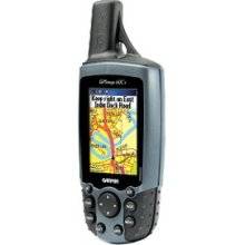
GPSMAP 60Cx - Hiking GPS receiver - 2.6" color - 1
Model: 60Cx
Brand: Garmin
The GPSMAP 60Cx is a refreshing upgrade of the GPSMAP 60C, one of the most popular Garmin\'s models for outdoor and marine use. This unit features a removable microSD card for detailed mapping memory and a waterproof, rugged housing. The microSD card slot is located inside the waterproof battery compartment. Users can load map data and transfer routes and waypoints through the unit\'s fast USB connection. In addition, this unit features a new, highly sensitive GPS receiver that acquires satellites faster and lets users track their location in challenging conditions, such as heavy foliage or deep canyons. Considered the mainstay among serious outdoor enthusiasts, the GPSMAP 60Cx offers a large color TFT display and turn-by-turn routing capability. The unit comes with a blank 64 MB microSD card. « less
Product Specifications –
- Product Type : GPS receiver
- Preloaded Maps : Canada, USA
- Part Numbers : 010-00421-00, 60Cx
- Waypoints : 1000
- Waypoints per route : 500
- Weight : 7.5 oz
- Width : 2.4 in
- Waterproof Standard : IPX7
- Warm : 1 sec
- Trip Computer : TracBack, average speed, maximum speed, trip timer, trip distance, sunrise/sunset times, sun/moon positions
- Tracklog Points : 10000
- Tracks : 20
- Update Rate : 1/second
- Type : TFT - color
- Type : Alkaline - AA type
- Resolution : 160 x 240
- Recommended Use : Hiking
- Receiver : 12 channel
- Protection : Waterproof
- Run Time (Up To) : 30 hours
- SBAS : WAAS
- Routes : 50
- Menu Language : English, French, Portuguese, Spanish
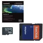
- Included Accessories : PC cable, belt clip, lanyard, USB cable, 64 MB microSD Card
- Height : 6.1 in
- Interface : Serial, USB, NMEA 0183, RTCM SC-104 DGPS
- Included Software : MapSource Trip & Waypoint Manager
- Interfaces : Serial - USB Serial - RS-232 Antenna - MCX
- Antenna : External
- Accuracy : Position - 33 ft Velocity - 0.16 ft/sec Position - 16 ft ( with DGPS ) Velocity - 0.16 ft/sec ( with DGPS )
- Card Reader : microSD
- Depth : 1.3 in
- Diagonal Size : 2.6"
- DGPS : DGPS ready
- Display Illumination : Yes
- Compatible Software : MapSource BlueChart, MapSource US TOPO 24K, MapSource Fishing Hot Spots, MapSource Recreational Lakes, MapSource City Navigator
- Cold : 38 sec
- First Seen On Google Shopping : December 2005
- Features : Backlit keypad, optional external GPS antenna connection, alarm, games, clock, custom POIs, preinstalled POIs
- Functions & Services : Bearing, distance, MOB (Man Overboard), heading, speed, time/date
- Grids : UTM, MGRS, Lat/Lon, UPS, User, Loran TDs, Maidenhead
- GTIN : 00053759049097, 00753759049096, 00753759049119, 00812147013856