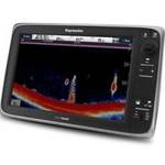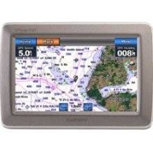
GPSMAP 640 - Marine, automotive Chartplotter - 5.2
Model: 640
Brand: Garmin
With the Garmin GPSMAP 640, you\'ll get a full-featured marine chart plotter and an on-the-road navigator. The GPSMAP 640 comes standard with a high-sensitivity GPS receiver and brilliant, high-resolution touch screen display so you\'ll always know the way whether you\'re on land or at sea. « less
Product Specifications –
- Part Numbers : 010-00696-40, 640
- Preloaded Maps : Canada, USA, Puerto Rico
- Product Type : Chartplotter
- Type : Lithium ion
- Type : LCD - color - touch screen
- Voice : Voice command recognition
- Trip Computer : Sun/moon positions
- Tracklog Points : 10000
- Tracks : 20
- Resolution : 800 x 480
- Recommended Use : Marine, automotive
- Protection : Waterproof
- Run Time (Up To) : 9 hours
- Routes : 50
- Width : 5.9 in
- Weight : 17.3 oz
- Waypoints : 1500
- Waterproof Standard : IPX7
- GTIN : 00753759083557
- Height : 4 in
- Included Accessories : Protective cover, AC power adapter, power/data cable, marine mount, USB cable
- Included Software : Garmin Worldwide Marine Basemap, Garmin City Navigator North America NT
- Interface : NMEA 0183
- Interfaces : Antenna Headphones / line-out
- Antenna : Built-in
- Card Reader : SD Memory Card
- Compatible Software : BlueChart g2 Vision
- Depth : 1.9 in
- Diagonal Size : 5.2"
- First Seen On Google Shopping : October 2008
- Features : Alarm, 2D / 3D map perspective, XM weather support, custom POIs