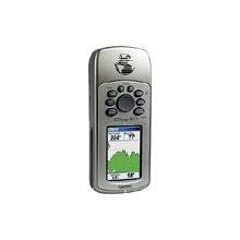
GPSMAP 76CS - Marine, hiking GPS receiver - 2.6" c
Model: 76CS
Brand: Garmin
All other marine handheld GPS units will pale when compared to the GPSMAP 76CS - literally. The latest color-display technology gives both units the brightest, sunlight-readable displays available. And with brand-new state-of-the-art receivers and powerful microprocessors, these units will give you a quick and steady fix. In addition, the GPSmap-76CS boasts a built-in electronic compass and barometric altimeter. The GPSMAP 76CS has the familiar GPS 76-family keypads and styling, with 115 MB of memory, an Americas Autoroute basemap, and a Marine Point database. Fast USB connectivity makes loading charts and maps quick and easy, while navigation instructions can be shared with repeaters, plotters, and autopilots using NMEA protocols through the dedicated serial port. It\'s waterproof and fully compatible with MapSource products like BlueChart, U.S. Topo 24K, and City Select (which provides detailed streets for turn-by-turn guidance). « less
Product Specifications –
- Preloaded Maps : South America, Canada, USA, Alaska, Central America, Mexico
- Part Numbers : 010-00353-00, 010-00353-01, 76CS, GPSMAP76CS
- Warm : 15 sec
- Waterproof Standard : IPX7
- Width : 2.4 in
- Waypoints : 1000
- Waypoints per route : 250
- Weight : 5.4 oz
- Update Rate : 1/second
- Type : AA type
- Type : LCD - color
- Tracklog Points : 10000
- Tracks : 20
- Trip Computer : TracBack, average speed, maximum speed, trip timer, trip distance, sunrise/sunset times, sun/moon positions
- Routes : 50
- Run Time (Up To) : 30 hours
- SBAS : WAAS
- Resolution : 160 x 240
- Receiver : 12 channel
- Recommended Use : Marine, hiking
- Product Type : GPS receiver
- Protection : Waterproof
- Max Operating Temperature : 158 °F
- Min Operating Temperature : 5 °F
- Height : 6.1 in
- Included Accessories : PC cable, lanyard
- Included Software : MapSource Trip & Waypoint Manager, Garmin Marine Point Database (Americas), Garmin Americas Autoroute Basemap
- Interface : Serial, USB, NMEA 0183, RTCM SC-104 DGPS
- Interfaces : Serial - RS-232 Serial - USB Antenna - MCX
- Internal Memory : 115 MB flash
- Accuracy : Position - 49 ft Position - 10 ft - 16 ft ( with DGPS ) Position - 10 ft ( with WAAS ) Velocity - 0.16 ft/sec
- Antenna : Built-in
- Cold : 45 sec
- DGPS : DGPS ready
- Diagonal Size : 2.6"
- Depth : 1.3 in
- Display Illumination : Yes
- Functions & Services : Electronic compass, elevation, MOB (Man Overboard), ascent/descent rate
- GTIN : 00753759045104
- Grids : UTM, MGRS, Lat/Lon, User, Loran TDs, Maidenhead
- Features : Barometric altimeter
- First Seen On Google Shopping : April 2004