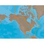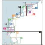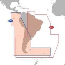
Max Electronic Chart - South America - Costa Rica
Model: SA-M500
Brand: C-Map
Mfr: C-MAP Electronic Charts - SA-M500; MAX Electronic Charts for South America let you navigate Latin America with C-Map\'s most accurate maps with their fastest performance from your chart plotters. C-Map creates electronic charts from official paper charts and adds features paper charts do not provide. Make your boating safer & more enjoyable with C-Map Max. An alarm sounds when any danger areas are detected. MAX charts pan chart areas & coastal roads seamlessly showing you bottom depths in 32 levels & land elevations in 15. MAX charts present all raster & simple vector chart information undiluted & with no manipulation of chart data or odd scaling. MAX charts provide seamless coverage allowing smooth panning between coverage layers of any given navigation area. MAX electronic charts let you choose North-up or Chart-up view options. The NavAids are presented in detailed, true color paper chart appearance. C-MAP Electronic charts are produced using official Hydrographic Office (HO) charts under the controls of ISO 9002 certified quality system. They are accurate to the best of C-Map\'s knowledge and any inconsistencies found are generally due to undetectable limitations in the HO charts themselves. Where due, Royalty Charges are included in C-CARD prices and paid to National Hydrographic Authorities. « less
Product Specifications –
- Part Number : SA-M500