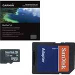
NA-M026 C-Card Format Great Lakes and The Maritime
Model: NA-M026
Brand: C-Map
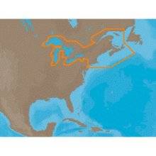
NA-M026 => Great Lakes, Northeast Coast and ApproachesCoverage of the Great Lakes, St. Lawrence River and Northeast United States. Coverage of the Great Lakes also includes Fox River and Lake Winnebago, Lake St. Clair, Rideau Canal, Ottawa River and the Trent-Severn Waterway. Includes all coastal charts for New Brunswick and Nova Scotia in Canada and Maine, New Hampshire, Massachusetts, Connecticut and New York in the U.S. Also included is coverage of the Hudson River and Lake Champlain as well as the Erie Barge Canal. Specifications:Port Plans: YesAerial Photos: Yes3-D View: Yes « less
Product Specifications –
- Part Numbers : 30127, NA-M026, NA-M026C-CARD
- GTIN : 000000165840, 00686074002791