Navi-Planner 4000
Navi-Planner 4000 sets a new standard for safe and efficient voyage planning. This innovative solution from Transas provides a single access point for all information needed for every step of the navigation process When developing the Navi-Planner 4000, Transas worked closely with oil company vetting-inspectors, ship owners and navigation officers. The result is a tool which makes voyage planning easy for navigators and efficient for ship owners. Navi-Planner 4000 complies with IMO Resolutions (IMO 1.916(22) Guidelines for the recording of events related to navigation and IMO A.893(21) Guidelines for Voyage Planning).
Purpose
Navi-Planner 4000 is recognized as the ECDIS markets most powerful charts management application, and also a set of databases, applications and services intended for voyage planning. Suitable both onboard as a 19back of the bridge 19 application, and ashore as a management tool Navi-Planner 4000 software creates a voyage plan using an electronic route editor, including:
Port to port planning of a complete voyage plan
AtoBviaC auto routing
Under Keel and Over Head Clearance
Route checking
Reference point selection
Reporting points
Warnings along the route
Chart listings for both (S)ENC and paper charts
Detailed voyage plan reports
Route export/import
Integration with Navi-Sailor 4000 ECDIS
Online correction service for paper charts and publications via TGT Services
Applications and Services
Quick Route with AtoBviaC distance tables
1CAtoBviaC distance tables 1D is a unique and powerful tool for basic route navigation planning. The routes are based on BP Distance Table and can be used for quick distance calculation, as a good tool for chart selection for (S)ENC Pre-licensing and as a basis for detailed route and voyage planning with Navi-Planner.
1CAtoBviaC distance tables 1D contains virtually thousands of alternate routes and a set of route calculation rules that can be set on/off by the navigator when setting up the route calculation.
Weather Functionality
The Weather Functionality in Navi-Planner is a service to assist the mariner on board in making the best decisions with regards to voyage planning in relation to weather conditions.
Advantages of onboard weather routing:
Fuel and speed optimization
Safety of crew and cargo
Situational awareness
Costs for meteorologists on shore are reduced
Reduced administration onboard and in the office
The weather data is supplied by Meteo Consult, a meteorological office that prepares a complete set of accurate weather information for standards ocean regions and coastal waters.
The data includes air pressure, wind and wave forecasts but also tropical storm forecasts, temperatures, precipitation, ice limits and much more.
Chart ordering and management
Transas offers a unique way of ordering and handling charts thru Navi-Planner. It can either be used for pre-licensing charts or as a Pay as you sail (PAYS) service. If pre-licensing is used, selection of charts to order can easily be made by a created route or a route loaded from the AtoBviaC auto routing functionality. The operator can select whether he wants to receive the license/permits only or receive the complete chart content from the server. During the preparation of the order a selection of license period can be made and the approximate cost of the order will be indicated.
Once the charts are received and installed, Navi-Planner will display a status report and then
synchronize the data to any other Workstation within the network.
If PAYS is used, a license holding all available PAYS SENC/ENCs is used and only charts that have been used for navigation will be charged.
Chart correction and management
As part of the chart management functionality in Navi-Planner, chart corrections can be ordered, installed and recorded both for (S)ENC 19s and paper charts. It is imperative for the Master to always have full control and overview for the vessels chart holdings and to be able to show this to authorities and inspectors.
As Navi-Planner operates with the Transas Chart Server directly or via email it offers the easiest way to access updates for charts used onboard.
Detailed waypoint and voyage planning
Transas Navi-Planner is as very powerful route planning tool. It is capable of everything from basic and simple route creation to full 1Ctrack control level C 1D planning as well as Route checking and 1CUnder Keel Clearance 1D (UKC) calculations based on set ships and safety parameters.
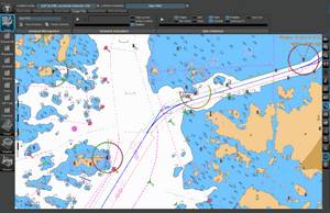
The main parts and functionality for route planning are for route geometry, schedule, additional information along the route as reference points, and metrological as well as hydrological data Routes, waypoints, Cross Track distances (XTD) and reference points can be created and edited either graphical or tabular. Route legs can be selected individually to be Rhumb-line Great-Circle based on WGS-84. Schedules can be calculated with or without speed limits for each route leg and including surface and tidal currents in the calculation.
Paper chart corrections
Did you know that Navi-Planner 4000 is not only capable of managing electronic charts and publications as part of your passage planning but also paper charts and paper publications. Within the program you can easily import your complete inventory or manually make a selection of paper charts held onboard. Navi-Planner can then directly connect to the Transas chart server ashore to gather all outstanding Notices to Mariners. You will get a clear overview of the status for your paper charts and any paper chart that may be used during your next voyage will automatically be listed in the passage plan, very easy and very safe.
Piracy Information Overlay
Transas 18Piracy Information Overlay 19 brings you credible piracy intelligence from recognised sources around the world. Using Navi-Planner, the piracy events for the last 365 days are available to view 24/7 as an information overlay to complement your existing company account features. Piracy Information Overlay provides the user with up to date information, essential for planning avoidance measures when travelling through a potential piracy area. The PIO data service is automated and updated at a minimum of 24 hour intervals.
Advantages
The market 19s fastest and most powerful chart management application
Everything you need for voyage planning and navigation management
Digital services managed in one application
Built-in paper chart and publication corrections
Full voyage planning, port-to-port and berth-to-berth
Developed through co-operation with customers and authorities
Made to support ISM procedures and bridge administration