Navionics Nav Plus East MSD Regional Lakes And Coa
Model: MSD/NAV+EA
Brand: Navionics
Price: $149 Supplier: Consumer Marine Supply
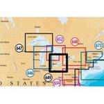
Navionics Nav Plus MSD Card East Regional Lake and Coastal Charts Navionics Nav Plus Regional MSD Card North
Model: MSD/NAV+EAUPC: 821245977069
- Marine and lake charts
- One foot contours
- Daily updates and advanced features for one year
Boat safer and fish smarter. Max-detailed cartography for marine and lakes that is updated daily, makes Navionics+ the perfect choice for cruising and fishing. Get the most accurate navigational data, an exclusive 1 ft HD bathymetry map, and local content from the community. Daily updates and advanced features: SonarChart™ Live, Advanced Map Options and Plotter Sync, are included for one year. USB reader provided.
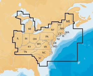
CT, DE, IL, IN, KY, MA, MD, ME, MI, NC, NH, NJ, NY, OH, PA, RI, SC, TN, VA, VT and WV. 7,000 lakes and growing. Full marine coverage, plus US waters of the Great Lakes