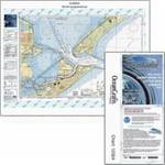
Paper Chart Kit Book REGION03 New York to Nantucke
Model: REGION03
Brand: Maptech
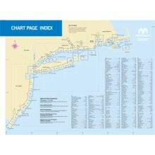
Completely updated. Coastal and offshore coverage. Full-color charts, GPS waypoints, courses and distances, Yeoman points, and color aerial photos. Save hundreds of dollars on charts. 22 X 17, 90 chart pages. Product Overview New features make ChartKits easy to use with your GPS. Most charts include one-minute lat./long. grids to make vessel positioning a breeze, and major navigation aids are identified with named GPS waypoints. GPS Ready New features make ChartKits easy to use with your GPS. Most charts include one-minute lat./long. grids to make vessel positioning a breeze, and major navigation aids are identified with named GPS waypoints. Small and Large Scale Charts ChartKits include small-scale, wide area charts as well as large-scale, detailed charts of harbors and approaches. « less
Product Specifications –
- Part Number : PAPREGION03