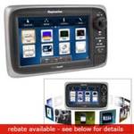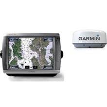
Radar 5212 Package with GMR18 4KW Radome
Model: GMR18
Brand: Garmin
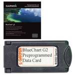
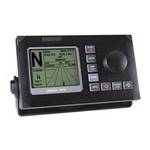
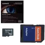
The package includes Garmin GPS Chartplotter Garmin GPS Antenna Garmin Radome Garmin Power, GPS, and Radar cables Manuals This flagship marine navigator is missing just one thing buttons. The GPSMAP 5212 features an unprecedented touchscreen interface, along with preloaded BlueChart g2 maps of the U.S. coast and a whopping 12.1\" screen that makes navigation as easy as pointing your finger. By connecting to the Garmin Marine Network, you can add sonar, radar and weather. For even more advanced features, you can add the optional BlueChart g2 Vision card. View Detailed Graphics and Video The GPSMAP 5212 features highly-detailed BlueChart g2 marine cartography of the costal United States, including Alaska, Hawaii and the Bahamas. For other areas, the 5212 has a worldwide basemap with high-quality satellite images in place of more traditional maps. With the SD card slot, you can add additional maps without having to connect to a computer. The 5212? s huge XGA screen displays graphics with crisp, video-quality resolution. To keep tabs on your engine room or other area of your boat, you can also connect a live video feed with the 5212\'s video input/output options. Add Extras with BlueChart g2 Vision With the optional BlueChart g2 Vision SD card, you can add a whole new dimension of exceptional features to your chartplotter. 3D mariner\'s eye view or fish eye view provides you with a 3-dimensionsl perspective of map information, both above the waterline and below it. High-resolution satellite images and aerial photographs help you orient yourself in unfamiliar areas. Auto Guidance technology searches through all relevant charts to create a route you can actually follow one that avoids obstacles, shallow water, buoys and other obstructions. Connect to the Garmin Marine Network The 5212 connects easily to the high-speed Garmin Marine Network, so you can interface with additional MFDs and add remote sensors. Once connected, you can share information between the 5212 and other chartplotters on your boat. You can also add high-powered radar, sonar, and XM satellite weather and radio to your system. D, Jan, 2008 | Download NMEA 2000 Network Fundamentals, Rev. A, Jan, 2008 | Download Owner\'s Manual, Rev. B, Jul, 2007 | Download Quick Reference Guide, Rev. B, Jan, 2008 | Download EL Quick Reference Guide (Greek), Rev. B, Jan, 2008 | Download RU Quick Reference Guide (Russian), Rev. B, Jan, 2008 | Download Some downloads may require Adobe Acrobat Reader. Download a free copy here . « less
Product Specifications –
- Part Number : gmrpack36