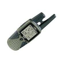
RINO 120 - Hiking GPS receiver / two-way radio - M
Model: 120
Brand: Garmin
The Rino 120 is state-of-the-art GPS navigation and two-way communications combined, with enough memory to download detailed mapping for driving, hiking, hunting, fishing - or just about anything else you can dream up. It\'s waterproof and can \"beam\" your exact location to another Rino user within a two-mile range (on the FRS spectrum) using \"Position Reporting\". The radio functionality of the Rino 120 provides two-way communications for up to two miles (using FRS channels), and you can talk to friends or family who own conventional FRS radios. There\'s also a voice scrambler and a vibration mode for silent calls. PRODUCT FEATURES: Channels: 22 (1-14 FRS, 15-22 GMRS); Squelch codes: 38; Range: Up to 2 miles on FRS channels; 5 miles on GMRS; Modes: Channel scan with programmable scan list; channel monitor; Call tones: 10 call and ring tones, 4 roger tones; VOX: External Voice Activation with sensitivity selection; Other features: Alarm, calculator, calendar, clock, lap timer, stopwatch, and games. « less
Product Specifications –
- Preloaded Maps : Canada, USA
- Part Numbers : 010-00270-02, 120, 628-4499, RINO120
- Recommended Use : Hiking
- Receiver : 12 channel
- Product Type : GPS receiver / two-way radio
- Protection : Waterproof
- Run Time (Up To) : 28 hours
- SBAS : WAAS
- Routes : 20
- Update Rate : 1/second
- Type : AA type
- Type : LCD - monochrome
- Tracks : 20
- Trip Computer : Average speed, maximum speed, trip timer, trip distance, sunrise/sunset times
- Waypoints : 500
- Weight : 8.3 oz
- Width : 2.3 in
- Waterproof Standard : IPX7
- Warm : 15 sec
- Included Accessories : PC cable, wrist strap, belt clip
- Height : 4.5 in
- Interface : Serial, NMEA 0183, RTCM SC-104 DGPS
- Included Software : Garmin Marine Point Database (Americas), Garmin Americas Highway Basemap
- Interfaces : Serial - RS-232
- Internal Memory : 8 MB flash
- Antenna : External
- Accuracy : Position - 49 ft Velocity - 0.16 ft/sec Position - 10 ft - 16 ft ( with DGPS ) Velocity - 0.16 ft/sec ( with DGPS ) Position - 10 ft ( with WAAS ) Velocity - 0.16 ft/sec ( with WAAS )
- Depth : 1.6 in
- DGPS : DGPS ready
- Cold : 45 sec
- Compatible Software : MapSource BlueChart, MapSource MetroGuide, MapSource Fishing Hot Spots
- Features : Downloadable POIs
- First Seen On Google Shopping : October 2003
- Grids : UTM, Lat/Lon, UPS, Loran TDs, Maidenhead
- GTIN : 00053759031962, 00689076597562, 00689076630887