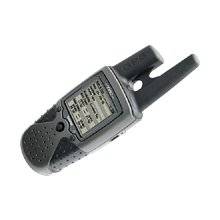
RINO 130 - Hiking GPS receiver / two-way radio - M
Model: 130
Brand: Garmin
The Rino 130 is the most feature-rich unit in the Rino family, with a built-in electronic compass, barometric sensor, weather receiver for seven NOAA weather channels, and 24 MBs of internal memory. This handheld radio has a built-in electronic compass to give a heading while the user is standing still, and a barometric altimeter to provide extremely accurate elevation and pressure information, which will assist users in identifying weather data. The Rino 130 provides two-way radio communication with a transmission range of up to two miles using FRS channels and up to five miles with GMRS. The integration of two-way radio and GPS enables users to transmit their position with a simple button press, allowing others to navigate to their position. The Rino 130 also has a polling feature, which allows a user to manually request GPS location information from other Rino units. « less
Product Specifications –
- Part Numbers : 010-00270-03, 010-00270-23, 130
- Preloaded Maps : North America, South America
- Warm : 15 sec
- Waterproof Standard : IPX7
- Width : 2.3 in
- Weight : 8.3 oz
- Waypoints : 500
- Trip Computer : Average speed, maximum speed, trip timer, trip distance, sunrise/sunset times, sun/moon positions
- Tracks : 20
- Tracklog Points : 10000
- Type : AA type
- Type : LCD - monochrome
- Update Rate : 1/second
- Routes : 20
- SBAS : WAAS
- Run Time (Up To) : 28 hours
- Protection : Waterproof
- Product Type : GPS receiver / two-way radio
- Receiver : 12 channel
- Recommended Use : Hiking
- Resolution : 160 x 160
- Max Operating Temperature : 158 °F
- Min Operating Temperature : -4 °F
- Internal Memory : 24 MB flash
- Interfaces : Serial - RS-232
- Included Software : Garmin Marine Point Database (Americas), Garmin Americas Highway Basemap
- Interface : Serial, NMEA 0183, RTCM SC-104 DGPS
- Height : 4.5 in
- Included Accessories : PC cable, wrist strap, belt clip
- GTIN : 00753759031978, 00753759042202, 00753759071028
- Grids : UTM, MGRS, Lat/Lon, UPS, Loran TDs, Maidenhead
- First Seen On Google Shopping : July 2004
- Compatible Software : MapSource BlueChart, MapSource US TOPO 24K, MapSource MetroGuide, MapSource Recreational Lakes, MapSource US TOPO
- Cold : 45 sec
- DGPS : DGPS ready
- Depth : 1.6 in
- Display Illumination : Yes
- Accuracy : Position - 49 ft Velocity - 0.16 ft/sec Position - 10 ft - 16 ft ( with DGPS ) Velocity - 0.16 ft/sec ( with DGPS ) Position - 10 ft ( with WAAS ) Velocity - 0.16 ft/sec ( with WAAS )
- Antenna : External